MARKETS

Case Study: GPS Integration into RiverRay

We are an Australian company with a growing international reputation
focusing on the design and servicing of high quality underwater
electronics used in harsh environments.

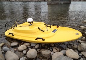
Hemisphere A100 Smart Antenna DGPS integrated into RiverRay

Many users prefer to integrate a GPS into RiverRay for difficult conditions such as moving beds. The RiverRay is fully DGPS compatible and supports integration of a large number of OEM GPS units. The advantage of this approach is that customers can integrate a GPS unit that they already have in their inventory – there is no requirement to include a dedicated GPS in the RiverRay that may not be used for many applications. This reduces cost of ownership.

The RiverRay boat is wired to accept GPS and routes it into the hull via a water proof connector. The GPS data is interleaved into the RiverRay data stream so a single port is all that is required to transmit the data back to your shore station. The result is that GPS and ADCP data are well synchronised.

Differential GPS (DGPS) is recommended with the RiverRay. Differential correction sources commonly available in Australia include RTK (Real-Time Kinematic), and the OmniStar/MarineStar correction services. RTK typically requires dual GPS receivers and a communications link between them, whereas OmniStar/MarineStar only requires a single less expensive receiver.
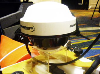
Trimble SPS 351 DGPS integrated into RiverRay
Hemisphere A100 Smart Antenna DGPS integrated into RiverRay

Trimble SPS 351 DGPS integrated into RiverRay

Many users may prefer to select dual frequency RTK GPS units that provide for operational advantages and big increases in productivity in the field. With a dual frequency RTK GPS the base station will converge in approximately 5 minutes and the rover (RiverRay boat) in less than 60 seconds. This can be compared to single frequency RTK units that can require 5 minutes for the base station to converge and a further 5 minutes or more for the rover to converge on differential corrections. If power is cycled or radio communications are lost the rover may need to converge again and this can sometimes take up to 20 minutes. The result can be a frustrating day.

BlueZone Group is pleased to offer the

Fugro Marinestar Differential Global Navigation Satellite System (DGNSS) and corrections signal services. These services can be provided at-sea and for any on-water activities including RiverRay work in lakes, rivers and all inland and estuarine waterways.

Latest News

Blueprint Subsea’s Artemis HHS Takes the Spotlight on 7 News!

Innovation and execution! Improving Search and Recovery for QLD Police Divers    Revolutionising the future for police diver operations, we are thrilled to share Blueprint Subsea’s Artemis HHS has been...

Read More

AHA 2025 Event – Launceston

AHA 2025 Event – Launceston   On our mission to stay ahead of the tide, this month the BlueZone team had the pleasure of attending ‘The Australian Hydrographers Association (AHA)’...

Read More

BlueZone Group Proudly Represents Xeos by Satlink in Australia

Supporting Innovation and Sustainability in Ocean Technology   The commitment to innovation driven sustainability is at the forefront of BlueZone’s values. As the proud, exclusive agent of Xeos by Satlink...

Read More

Welcome to the Team – Alana!

We’re excited to welcome a new face to the BlueZone Group, Perth, office – please join us in extending a warm welcome to Alana, who has joined the team as...

Read More